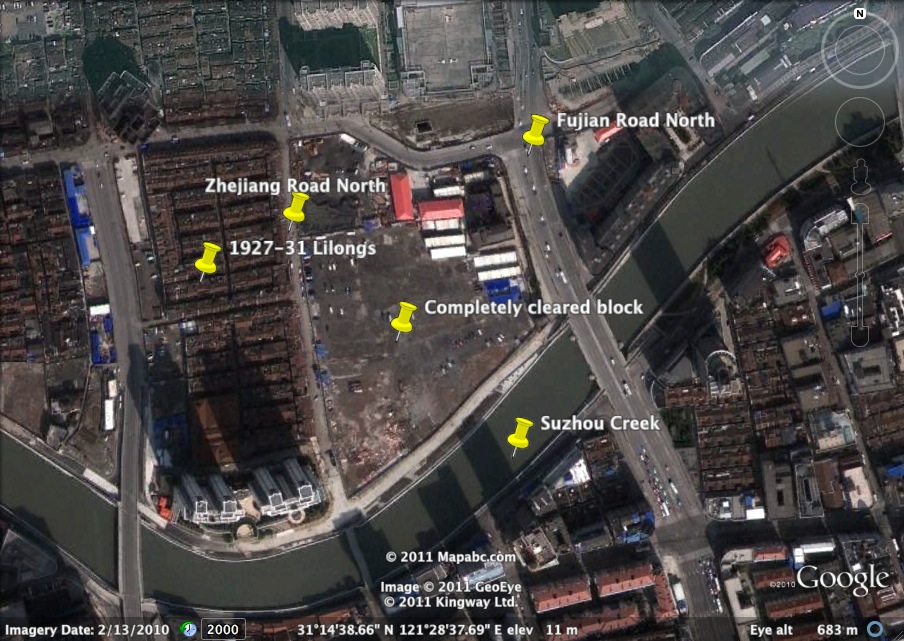
Fujian Road North Clearances From Above
Posted: February 9th, 2011 | 6 Comments »I noted in a previous post the loss of a major block alongside the banks of Suzhou Creek and the bulldozing of perfectly refurbishable lilongs and shikumen along Fujian Road North (Fokien Road North) that had been left to rot for several years to allow for demolition. This Google Earth image, I think, shows just how much was cleared on this plot and how vulnerable the blocks (constructed between 1927-31) fronting onto Zhejiang Road North (Chekiang Road North) are now.
I think the notes of map is not correct,The “Fujian Road North” should be Henan Road Middle”, The ” Zhejiang Road North Should be Shanxi Road Noth” and so on, The “Completely cleared block” should was “Sandeli”(三德里)…
At least they spared that (now lonely) gatehouse on the end of the block and a building behind it – at least I hope that’s the case. Any idea what that building/gatehouse used to be?
You mean Shanghai general chamber of commerce’s gatehouse?(上海总商会)
Is that what it is? I suppose it would explain its existence. It’s on the bottom-right corner of the cleared block, on the corner of Henan and Suzhou Bei lu, has this sort of Roman triumphal arch vibe going on
This one? Yes, pls check this photo:
http://www.douban.com/photos/photo/676776390/
Yep that’s the one